|
| |
 The East Cliff is the start of the Firehills Country Park , which provides
cliff top walks unbroken by roads to the village of Fairlight about 5 miles
to the East. The East Cliff is the start of the Firehills Country Park , which provides
cliff top walks unbroken by roads to the village of Fairlight about 5 miles
to the East.
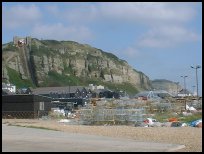
The cliff top has been inhabited from the stone age to the present . The
remains of a stone age encampment has been found, together with a
Roman Outpost whose purpose was to warn of impending attacks ,or visits
by cargo ships or Generals and Emperors from Europe.
The cliffs during the age of local smuggling were used to wreck vessels,
this was carried out by placing false harbour lights on the cliffs which
were used draw the victims onto the rocks ( see Fairlight ).
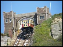
To get to the cliff top, you can walk the many flights of steps from the
Old Town via the Tackleway to the top, or for those requiring an easier
for of transport, you can take the cable railway from the harbour to the
top. The Cable railway was built in the 1800's and was then powered by
spring and rain water fed into a tank under the top carriage, whose weight
took the top carriage down and the visitors up.
|
|
 From the top of the cliffs on a clear day you can see the coast of France. From the top of the cliffs on a clear day you can see the coast of France.
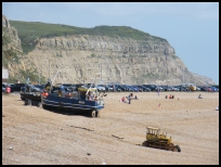
Walking from the cable railway towards Fairlight , you pass along the
cliff top , which is very pretty. The area is also nice to take a picnic
to, but be careful to take all your rubbish away with you, as the area
is quite flammable in the summer.
Looking down on the old town is quite spectacular, with the old narrow
streets and rooftops contrasting with the grass and the rocks of the
West Hill . |
|
 There is only the cable railway to service the area, although an ice cream
van can be found at the top in the summer. There is only the cable railway to service the area, although an ice cream
van can be found at the top in the summer.
Dog walkers and ramblers find the cliff top walk from Hastings to Fairlight
absolutely fabulous on warm summer days. |
|
| Hastings East Cliff is shown as the red symbol on the map. |
|
|
Nearby Villages
(click on symbol to see the village page) |
| Village= | |
Town= | |
Recorded in Domesday= |  |
| |
|
|
Battle |
(William the Conqueror prevails) | | 6.71 miles |
|
|
Crowhurst |
(Village devastated by the Normans) | | 5.17 miles |
|
|
Fairlight |
(Firehills and Views) | | 2.02 miles |
|
|
Guestling |
(Changing guards at Buckingham Palace) | | 2.52 miles |
|
|
Hastings Bulverhythe |
(Landing place of the citizens) | | 4.14 miles |
|
|
Hastings Old Town |
(The ancient Cinque Port) | | 1.26 miles |
|
|
Hastings Ore |
(Iron and the Turnpike) | | 0.33 miles |
|
|
Hastings Sea Front |
(Modern amusements,pier and promenade) | | 3.40 miles |
|
|
St Leonards on Sea |
(an Edwardian family's gentile resort) | | 2.86 miles |
|
|
Icklesham |
(Paul McCartney's Recording Studio) | | 4.26 miles |
|
|
Old Winchelsea |
(Abandoned after the Great Storm) | | 6.24 miles |
|
|
Pett |
(End of the Royal Military Canal) | | 2.88 miles |
|
|
Westfield |
(Bonfire Boys under suspicion) | | 3.33 miles |
|
|
Winchelsea |
(Inland Cinque Port !!) | | 5.75 miles |
|
|
Winchelsea Beach |
(Holidaymakers and Henry VIIIs Fort) | | 5.84 miles |
|
|


